Although there is no recorded settlement at Wombourne in Saxon times, it seems likely that some communities remained after the Roman camps in the area were abandoned by the 5th century. The discovery of four barrows in Wombourne Parish in the 18th century led the antiquary Richard Wilkes to conclude that the Common had been the site of the famous Battle of Tettenhall, despite the location being around six miles from the present day village of Tettenhall. In 910 AD the battle was an important victory for the Mercian and Wessex alliance against the Vikings and heralded the end of invasions in England from the north. The exact location of the battlefield is still unknown and Wilkes’ theory led to the area directly south east of the current village being called ‘Battlefield’ from the 19th century.
The earliest records show that in preConquest Wombourne, Turstin, a Saxon Thane or Lord, held seven hides of land and administered the law in the area through the ancient right of sac and soc. A hide was an early measurement of land based on yield rather than size. One hide would produce enough food to support one household. This would equate to between six and twelve hectares, depending on fertility. By 1086, Domesday recorded that there were 26 people living in Wombourne and that there was a church already established. William Fitzansculf, lord of Dudley, held this and neighbouring manors descended through the Dudley and Sutton families over the next few centuries. Cultivation was already extensive in the 11th century with eight plough teams at Wombourne working the light soil.
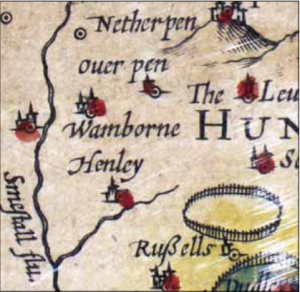
The overlords presided over a sparsely populated area that relied solely on the produce of the land for its sustenance. The Wom Brook, which gave the village and parish its name, provided the power for two mills by 1086. The village appears to have changed little during medieval times and the parish still only had 37 households by 1563. However, the village began to take shape by this time as references to a green are recorded in the 13th and 14th centuries. Also, farming had developed to include the growing of rye, barley, peas and oats as well as the grazing of goats and sheep by the 14th century.
From this time the village had access to a good trading route: the road between Stafford and Worcester (now the A449) skirts the village. The manor was regularly traded by the 16th and 17th centuries until it was sold to Walter Wrottesley in 1641 and, along with other land in neighbouring villages such as Swindon, was passed down to successive Wrottesleys into the 19th century.
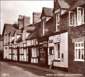
The population of Wombourne only began to increase rapidly when the Staffordshire & Worcestershire Canal was constructed west of the village by James Brindley and opened in November 1770. It was at this time that the people of Wombourne became established as nailers. Nail making was concentrated in and around the village from the early part of the century and the population rose steadily to reach 1,530 (in the township) and 2,236 (in the parish) by 1861. Iron making had come to the area in the late 16th century and there was a hammer mill at Greensforge in 1602. By this time there were three forges in the parish and iron making continued until 1976. However, the early 19th century proved to be a golden era for the village – there were 18 nailshops in Wombourne,some of them in the centre of the village and a nail warehouse in Rookery Lane. The nail trade declined after the 1850s and many people were forced to move elsewhere to find employment. There were no nailers left in the parish at all by 1889.

Despite this decline, Wombourne continued to have a successful horticultural industry that had grown steadily. Market gardens were introduced in the 18th century and crops such as parsnips and turnips have been grown ever since. Natural resources were also exploited in the area from the 19th century as sand and gravel pits were dug. Quarries were not worked out until the end of the 20th century. Also, milling continued successfully in the area from medieval times through to the 20th century, harnessing the power of both the Wom Brook (at the nearby Wodehouse) and the Smestow Brook at Smestow Mill, as well as the wind, as windmills stood at various locations around the parish, including one on School Road in 1840. Another important industry was that of malting, which initially took place at Woodhouse in the 17th century where the corn mill had been converted into a malthouse, and then in Walk Lane by 1861.
During the boom period of the mid 19th century a strong sense of community developed in the village, which is evidenced by the formation of a Cricket Club (c.1860), a Reading Association (1854) and the Wombourne Mutual Improvement Society (1863). The Associations acted as lending libraries and organised regular social evenings and concerts at the National School in School Road. Also at this time there was a choral society, a rifle band and, during the 1870s, the Wombourne Cottagers’ Horticultural Society, which held annual flower and vegetable
shows. Many other societies established themselves in this busy community at this time, mostly involved in rural pursuits. The church was rebuilt twice and remained as a beacon of the village’s prosperity. Also, a National School had been built to the west of the Church in 1833 and this was supplemented by four private day schools in Wombourne in the same year. The active community led to the formation of an industrious parish council, which formed a fire brigade in 1898.
Due in part to the downturn in the nail trade during the later 19th century, no railway line was initially built to serve Wombourne. However, work on the Wolverhampton & Bridgnorth Railway began in 1913. Wartime shortages of labour and materials called a halt to this in 1916, but work resumed in 1921, and the line opened on 11 May 1925. The station was north of Bratch Road and, therefore, was a considerable walking distance from the centre of the village. The scheme was short lived and passenger services were withdrawn on 31 October 1932, and the line was last used on 24 June 1965. The track was lifted between June 1967 and January 1968, and the route now provides another kind of amenity to the local people in the form of the South Staffordshire Railway Walk, a ten-mile rural hike.

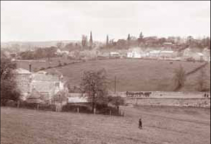
During the early 20th century Wombourne’s population began to rise again as it established itself as a convenient dormitory settlement close to the large industrial conurbations of Wolverhampton, Dudley and Stourbridge.
The proximity of the A449 became an increasing benefit to those who needed to commute to work. The interwar period saw the prominence of Wombourne rise on the local political map as the Seisdon Rural District Council relocated there from Trysull in the early 1930s. Local traditions such as the annual flower show were revived and continued until the late 1960s. In the ten years following 1951, the parish’s population grew from 3,838 to 9,974 and in 1968 a magistrate’s court was opened in the village. In 1976 the newly formed South Staffordshire District Council relocated to Codsall, however, it remains one of the largest villages in the country with many modern estates, council and private, having been built, and a considerable amount of light industry and factories becoming established on its periphery.
There is the suggestion of prehistoric settlement in the area from the discovery of post-Mesolithic flints in nearby Greensforge Farm. However, communities were generally transient in this era, being grouped into bands of hunter-gatherers, and would rarely have settled in one area for long, but moved around with the seasons and the opportunities to find food and other provisions. It is possible that settlements were established late in the Neolithic era when farming techniques began to be established. The area is abundant with rich fertile soil that is particularly suitable for cultivation.
No significant Roman finds have been found in Wombourne, although a Roman road ran through the southwest of the parish and 2nd century pottery has been discovered at Greensforge Farm.